Neighborhood
Mardin Old Town
A city of honey-colored stone above the Mesopotamian plain: Artuqid madrasas, a Syriac monastery that was…
Photo: Turkey Your Way
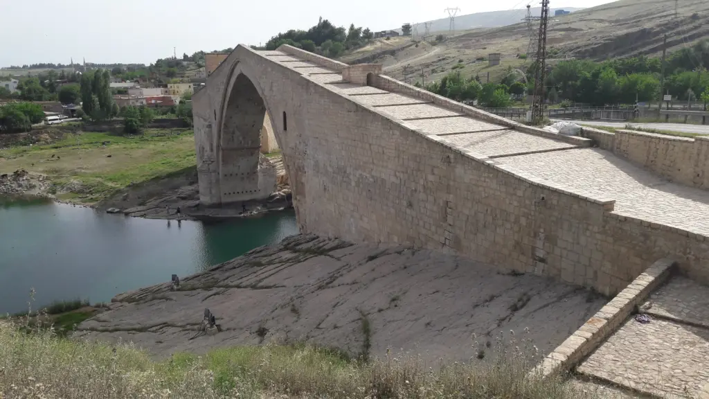
One of the widest stone arches of the medieval Near East, built by the Artuqids of Mardin, with guard rooms hidden in its masonry.
In the 1600s, the traveler Evliya Çelebi watched guests sit in the windows of a bridge over the Batman River. Some chatted with people across the arch, while others dropped nets and fishing lines into the water below. That bridge was the Malabadi Bridge, and its great pointed arch still leaps over the river near Silvan.
The Artuqid rulers of Mardin built it in the 12th century. When the French scholar Albert Gabriel saw it, he wrote that the dome of Hagia Sophia would fit under its arch. So come for the span, then climb the ramp and look for the rooms hidden inside the bridge.
The Malabadi Bridge crosses the Batman River near the village of Malabadi, in the Silvan district of Diyarbakır province. The river here also forms the border with Batman province. Diyarbakır lies about 104 km (65 miles) to the west, on the old road toward Bitlis and Van.
The bridge is about 150 meters (490 feet) long and 7 meters (23 feet) wide. Its main arch spans 38.6 meters (127 feet) and rises 19 meters (62 feet) above low water. Turkish sources call it the widest arch of any stone bridge in Turkey and the Near East. In Adana, see Taşköprü, the Roman bridge over the Seyhan. Since 2016 it has been on the UNESCO tentative list.
An older bridge stood here from 668 until floods brought it down in 1144. Then, in 1146 or 1147, the Artuqid ruler Husam al-Din Timurtash ordered a new one. His first builder, al-Zahid, finished the eastern footing, but a flood swept it away, so the ruler fined him for “defective craftsmanship”.
After that, a new team restarted the work with massive timbers to support the arch. By 1153 the bridge was nearly finished, although the arch was still open when Timurtash died in January 1154. His successor, Najm al-Din Alpi, finally closed it, even though floods interrupted the work once more.
The inscriptions and old sources call the bridge Akarman, or Karaman. Later, local people began to call it Malabadi, after Bad, the founder of the Marwanid dynasty. In Kurdish the name means “the house of Bad”. In 1932 Albert Gabriel and the epigraphist Jean Sauvaget read an inscription on it in the name of Timurtash, dated 1147 or 1148.
For centuries this was the only bridge across the river in the area, so travelers on the roads between Diyarbakır, Bitlis and Mardin crossed here. Builders repaired it late in the 12th century and again early in the 20th century. It carried traffic until the 1950s, when a new road bridge opened upstream, and the Silvan municipality restored it in 1989.

Stand on the riverbank below the bridge to see the pointed main arch at its best. Its builders used stone of several colors. Because the roadway meets the river at an angle, the approaches bend on both banks, while small arches in the ramps let floodwater through.

On both sides of the main arch, builders hid small rooms in the masonry, each about 4.5 meters (15 feet) to 5.3 meters (17 feet) long. Travelers and bridge guards used them as shelter, especially in winter. Stairs lead down to them from the roadway, and their windows are wide. Tunnels once carried the footsteps of approaching caravans to the guards.

At the top of the arch, a stone gateway about 5 meters (16 feet) wide once controlled traffic, and a toll booth stood on each side of the main span. Look also at the western pier in the river, where two figures are carved into the stone, one standing and one sitting.

When Evliya Çelebi crossed, iron gates like those of a castle closed both ends. He also described inns below the arch, rooms with iron-barred windows and railings of fine steel. Today the bridge still appears on the logo of the town of Silvan.

Our notes for the bridge
Our suggestion Stop on the road between Diyarbakır and Batman, walk up and over the arch, and look for the windows of the rooms inside the piers.
For more of the region, see our Southeastern Anatolia page.
Because a ruler once fined his builder for a flood. Stand under the arch Gabriel compared to Hagia Sophia, walk over the top, then find the travelers' rooms and the two carved figures on the western pier.
Neighborhood
A city of honey-colored stone above the Mesopotamian plain: Artuqid madrasas, a Syriac monastery that was…

Open in Google Maps (opens in a new tab) Open in Apple Maps (opens in a new tab)
The Artuqid ruler Husam al-Din Timurtash began it in 1146 or 1147, and his successor Najm al-Din Alpi finished the arch after 1154.
The main arch spans 38.6 meters (127 feet) and rises 19 meters (62 feet) above low water.
Local people named it after Bad, the founder of the Marwanid dynasty; in Kurdish, Malabadi means the house of Bad.
Yes. Cars have used a newer bridge upstream since the 1950s, so the old roadway is a walk.
It is on the UNESCO tentative list, where Turkey placed it in 2016, but it is not yet on the World Heritage List.